Pacemaker Fishing Forum
Welcome Aboard!
You are not logged in.
#1 Feb-07-10 5:45AM
- captmikestarrett
- Patagonian Toothfish

- From: Potomac River
- Registered: May-06-08
- Posts: 2183
- Website
Round #2 of snow
The NAM models and the throwing of the bones are not sure yet ,, but it looks like another snow storm on the way for Tues. /Wed and early Thur.
Could be a record for DC area..
Capt Mike
Light Tackle Fishing Guide on the Potomac
Offline
#2 Feb-07-10 6:13AM
- Ernie
- Administrator
- From: Ashburn VA
- Registered: Feb-03-06
- Posts: 15641
Re: Round #2 of snow
Record as in total from all the recent snow combined or record as in an individual storm? My brother, an ametuer weatherman/air traffic conosseur is calling this the Congoline Syndrome. You know, cha cha cha cha CHA....snow snow and more snow.
If the latter, I am going to Miami!
Time to go fishin' again!
Offline
#3 Feb-07-10 6:31AM
- captmikestarrett
- Patagonian Toothfish
- From: Potomac River
- Registered: May-06-08
- Posts: 2183
- Website
Re: Round #2 of snow
The record the weather man on the tube said it was for total snowfall in a winter season..
Capt Mike
Light Tackle Fishing Guide on the Potomac
Offline
#4 Feb-07-10 10:35AM
- captmikestarrett
- Patagonian Toothfish
- From: Potomac River
- Registered: May-06-08
- Posts: 2183
- Website
Re: Round #2 of snow
Capt Mike
Light Tackle Fishing Guide on the Potomac
Offline
#5 Feb-07-10 4:05PM
- Ernie
- Administrator
- From: Ashburn VA
- Registered: Feb-03-06
- Posts: 15641
Re: Round #2 of snow
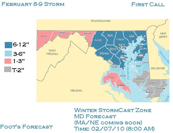
The Capital Weather Gang sez about the next storm:
Precipitation, primarily snow as it looks now but maybe mixed with sleet at the start, is on track to arrive Tuesday afternoon or evening. Snow, or briefly a snow/sleet mix, may be on the light side at first before probably becoming moderate to heavy overnight into Wednesday.
At least 4 inches is looking like a decent bet, with 8 inches or more a possibility. Here's our accumulation probabilities, which are likely to change as the storm gets closer:
15%: Less than 2"
25%: 2-5"
35%: 5-8"
25%: 8"+
Time to go fishin' again!
Offline
#6 Feb-08-10 1:06PM
- NOVAhunter
- Northern Snakehead
- From: Ashburn, va
- Registered: Mar-03-09
- Posts: 369
Re: Round #2 of snow
I'll say 15.5" at dulles and 6" at national for this one.
Offline